Keywords
Theme:
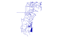
Canals
Place:
Miami-Dade County, Florida
Description
Abstract
Line feature class of Miami=Dade County Canals.
Purpose
To graphically display Miami-Dade County Canals for mapping purposes.
Supplementary Information
Revisions:
Date: May 2012     by DERM (RER)
Reason: To add minor Canal and Ditch features, primarily coastal Ditches in Coral Gables. Also updated Contact and Phone information.

Date: May 2011     by DERM
Reason: Primarily to display updated route of the North Line Canal southwest of the MIA.

Date: June 2009                By:DERM
Reason: To add minor Canal and Ditch features identified by DERM and PW that were not included. This update also includes a structure change where the field "COMMENTS" was added.  Structure change done July 2009 in production.

Date: October 2007           By: DERM
Reason: Data was recieved from the Department of Environmental Resources Management. Added new Contact.

Date: October 2006            By: GIS Technical Support Staff
Reason: The data was converted from the legacy coverage format to the ArcGIS Geodatabase feature class format.
_________________
Status of the data
Completed
Data update frequency: Annually
Data update frequency: Annually
Time period for which the data is relevant
Description:
Data is current as of the last update.
Publication Information
Who created the data: USGS
_________________
Data storage and access information
File name: MDC.Canal
Type of data: vector digital data
Server Information
Data processing environment: Microsoft Windows 2000 Version 5.2 (Build 3790) Service Pack 2; ESRI ArcCatalog 9.3.1.4000
Type of data: vector digital data
Location of the data:
Accessing the data
Size of the data: 0.323 MB
Data transfer size: 0.323 MB
Data transfer size: 0.323 MB
Constraints on accessing and using the data
Access constraints:
For public access
Use constraints:
None.
Details about this document
Contents last updated: 20120607
at time 15551800
Who completed this document
Charlton Lewis
Miami-Dade County , DERM
mailing address:
Miami-Dade County , DERM
mailing address:
701 NW 1st Court
Miami, FL 33136
Standards used to create this document
Standard name: FGDC Content Standards for Digital Geospatial Metadata
Standard version: FGDC-STD-001-1998
Time convention used in this document: local time
Metadata profiles defining additonal information
ESRI Metadata Profile: http://www.esri.com/metadata/esriprof80.html
ESRI Metadata Profile: http://www.esri.com/metadata/esriprof80.html
ESRI Metadata Profile: http://www.esri.com/metadata/esriprof80.html
Standard version: FGDC-STD-001-1998
Time convention used in this document: local time
Metadata profiles defining additonal information
Horizontal coordinate system
Projected coordinate system name: NAD_1983_StatePlane_Florida_East_FIPS_0901_Feet
Geographic coordinate system name: GCS_North_American_1983
Details
Map Projection Name: Transverse Mercator
Scale Factor at Central Meridian: 0.999941
Longitude of Central Meridian: -81.000000
Latitude of Projection Origin: 24.333333
False Easting: 656166.666667
False Northing: 0.000000
Longitude of Central Meridian: -81.000000
Latitude of Projection Origin: 24.333333
False Easting: 656166.666667
False Northing: 0.000000
Planar Coordinate Information
Planar Distance Units: survey feet
Coordinate Encoding Method: coordinate pair
Coordinate Representation
Abscissa Resolution: 0.000250
Ordinate Resolution: 0.000250
Geodetic Model
Horizontal Datum Name: North American Datum of 1983
Ellipsoid Name: Geodetic Reference System 80
Semi-major Axis: 6378137.000000
Denominator of Flattening Ratio: 298.257222
Altitude System Definition
Resolution: 1.000000
Encoding Method: Explicit elevation coordinate included with horizontal coordinates
_________________
Bounding coordinates
Horizontal
In decimal degrees
West:
-80.685585
East:
-80.120159
North:
25.982877
South:
25.259966
In projected or local coordinates
Left: 760073.269064
Right: 945205.211064
Top: 599592.778410
Bottom: 337676.031160
_________________
Lineage
FGDC lineage
Process step 1
Process description: EXTERNALALL
Source used: None
Source produced: None
Process date: 1990' 6'28 at time 1459
Source used: None
Source produced: None
Process date: 1990' 6'28 at time 1459
Process step 2
Process description: SPLIT D$GISPROD:[DADE.LINE]CANALS D$GISPROD:[DADE.POLY]USGS_QUADS USGS_QUADS-ID
Source used: None
Source produced: None
Process date: 1990' 9'25 at time 1545
Source used: None
Source produced: None
Process date: 1990' 9'25 at time 1545
Process step 3
Process description: SPLIT D$GISPROD:[DADE.LINE]CANALS D$GISPROD:[DADE.POLY]USGS_QUADS USGS_QUADS-ID
Source used: None
Source produced: None
Process date: 1990' 9'25 at time 1611
Source used: None
Source produced: None
Process date: 1990' 9'25 at time 1611
Process step 4
Process description: SPLIT D$GISPROD:[DADE.LINE]CANALS D$GISPROD:[DADE.POLY]USGS_QUADS USGS_QUADS-ID
Source used: None
Source produced: None
Process date: 1990' 9'27 at time 1048
Source used: None
Source produced: None
Process date: 1990' 9'27 at time 1048
Process step 5
Process description: EXTERNALALL
Source used: None
Source produced: None
Process date: 19911125 at time 1357
Source used: None
Source produced: None
Process date: 19911125 at time 1357
Process step 6
Process description: EXPORT COVER CANALS CANALS
Source used: None
Source produced: None
Process date: 1992' 9'26 at time 1224
Source used: None
Source produced: None
Process date: 1992' 9'26 at time 1224
Process step 7
Process description: EXTERNALALL
Source used: None
Source produced: None
Process date: 1993' 3'17 at time 0947
Source used: None
Source produced: None
Process date: 1993' 3'17 at time 0947
Process step 8
Process description: EXPORT COVER D$GISPROD:[DADE.LINE]CANALS CANALS
Source used: None
Source produced: None
Process date: 19930803 at time 1216
Source used: None
Source produced: None
Process date: 19930803 at time 1216
Process step 9
Process description: EXTERNALALL
Source used: None
Source produced: None
Process date: 19931227 at time 1240
Source used: None
Source produced: None
Process date: 19931227 at time 1240
Process step 10
Process description: EXTERNALALL
Source used: None
Source produced: None
Process date: 19931227 at time 1253
Source used: None
Source produced: None
Process date: 19931227 at time 1253
Process step 11
Process description: PROJECT COVER D$GISPROD:[DADE.LINE]CANALS CANALS GIS_DML5:[PRD83.DADE]NAD27_TO_
Source used: None
Source produced: None
Process date: 19940308 at time 2120
Source used: None
Source produced: None
Process date: 19940308 at time 2120
Process step 12
Process description: BUILD CANALS LINE
Source used: None
Source produced: None
Process date: 19940308 at time 2120
Source used: None
Source produced: None
Process date: 19940308 at time 2120
Process step 13
Process description: ESRI IMPORT COVER CANALS.E00 CANALS
Source used: None
Source produced: None
Process date: 19950822 at time 1619
Source used: None
Source produced: None
Process date: 19950822 at time 1619
Process step 14
Process description: ESRI RENAME CANALS ACANALS
Source used: None
Source produced: None
Process date: 19950922 at time 1502
Source used: None
Source produced: None
Process date: 19950922 at time 1502
Process step 15
Process description: GIS COPY /DATA/PRD/ACANALS
Source used: None
Source produced: None
Process date: 19950928 at time 1238
Source used: None
Source produced: None
Process date: 19950928 at time 1238
Process step 16
Process description: GIS IDEDIT ACANALS LINE
Source used: None
Source produced: None
Process date: 19951003 at time 1048
Source used: None
Source produced: None
Process date: 19951003 at time 1048
Process step 17
Process description: GIS IDEDIT ACANALS LINE
Source used: None
Source produced: None
Process date: 19951003 at time 1100
Source used: None
Source produced: None
Process date: 19951003 at time 1100
Process step 18
Process description: EXTERNALALL
Source used: None
Source produced: None
Process date: 19960829 at time 1449
Source used: None
Source produced: None
Process date: 19960829 at time 1449
Process step 19
Process description: GIS DOCUMENT ACANALS UPDATE GIS
Source used: None
Source produced: None
Process date: 19970203 at time 1020
Source used: None
Source produced: None
Process date: 19970203 at time 1020
Process step 20
Process description: GIS EXPORT COVER /ACANALS /ACANALS NONE
Source used: None
Source produced: None
Process date: 19980131 at time 0705
Source used: None
Source produced: None
Process date: 19980131 at time 0705
Process step 21
Process description: GIS DOCUMENT ACANALS UPDATE GIS
Source used: None
Source produced: None
Process date: 19981130 at time 1346
Source used: None
Source produced: None
Process date: 19981130 at time 1346
Process step 22
Process description: MDC DOCUMENT ACANALS UPDATE MDC
Source used: None
Source produced: None
Process date: 19991006 at time 0805
Source used: None
Source produced: None
Process date: 19991006 at time 0805
Process step 23
Process description: MDC DOCUMENT ACANALS UPDATE MDC
Source used: None
Source produced: None
Process date: 19991006 at time 0810
Source used: None
Source produced: None
Process date: 19991006 at time 0810
Process step 24
Process description: MDC DOCUMENT ACANALS UPDATE MDC
Source used: None
Source produced: None
Process date: 19991006 at time 0814
Source used: None
Source produced: None
Process date: 19991006 at time 0814
Process step 25
Process description: GIS DOCUMENT ACANALS UPDATE GIS
Source used: None
Source produced: None
Process date: 20010830 at time 1755
Source used: None
Source produced: None
Process date: 20010830 at time 1755
Process step 26
Process description: GIS DOCUMENT ACANALS UPDATE GIS
Source used: None
Source produced: None
Process date: 20010918 at time 1758
Source used: None
Source produced: None
Process date: 20010918 at time 1758
Process step 27
Process description: Metadata imported.
Source used: xml.tmp
Source used: xml.tmp
Process step 28
Process description: Dataset copied.
Source used: Server Information
Source used: Server Information
Process step 29
Process description: Metadata imported.
Source used: \\Canal.xml
Source used: \\Canal.xml
Process step 30
Process description: Metadata imported.
Source used: \\GIS_Apps\MetadataExports\Canal.xml
Source used: \\GIS_Apps\MetadataExports\Canal.xml
Process step 31
Process description: Dataset copied.
Source used: Server Information
Process date: 20081229 at time 14371100
Source used: Server Information
Process date: 20081229 at time 14371100
Process step 32
Process description: Metadata imported.
Source used: \\Canal.xml
Process date: 20090625 at time 16562200
Source used: \\Canal.xml
Process date: 20090625 at time 16562200
Process step 33
Process description: Dataset copied.
Source used: Server Information
Process date: 20110324 at time 09205800
Source used: Server Information
Process date: 20110324 at time 09205800
Process step 34
Process description: Metadata imported.
Source used: xml.tmp
Process date: 20110518 at time 15250100
Source used: xml.tmp
Process date: 20110518 at time 15250100
Process step 35
Process description: Metadata imported.
Source used: c:\temp\xml769.tmp
Process date: 20110526 at time 11540600
Source used: c:\temp\xml769.tmp
Process date: 20110526 at time 11540600
Process step 36
Process description: Metadata imported.
Source used: \\canals_2011.xml
Process date: 20110602 at time 09225000
Source used: \\canals_2011.xml
Process date: 20110602 at time 09225000
Process step 37
Process description: Dataset copied.
Source used: Server Information
Process date: 20110602 at time 19190300
Source used: Server Information
Process date: 20110602 at time 19190300
Process step 38
Process description: Metadata imported.
Source used: \\Canal.xml
Process date: 20120607 at time 15235800
Source used: \\Canal.xml
Process date: 20120607 at time 15235800
Sources
Source 1
Scale denominator: 24000"
ESRI geoprocessing history
1. Process
Date and time:
20110602
at time 094440
Tool location: C:\Program Files\ArcGIS\ArcToolbox\Toolboxes\Conversion Tools.tbx\FeatureClassToFeatureClass
Tool location: C:\Program Files\ArcGIS\ArcToolbox\Toolboxes\Conversion Tools.tbx\FeatureClassToFeatureClass
Command issued
FeatureClassToFeatureClass \\DSDE3_ruizj.sde\MDC.QC\MDC.Canal \\MDC.sde\MDC.Processing Canal # "NAME 'NAME' true true false 50 Text 0 0 ,First,#,\\DSDE3_ruizj.sde\MDC.QC\MDC.Canal,NAME,-1,-1;TYPE 'TYPE' true true false 75 Text 0 0 ,First,#,\\DSDE3_ruizj.sde\MDC.QC\MDC.Canal,TYPE,-1,-1;SFWMDNAME 'SFWMDNAME' true true false 10 Text 0 0 ,First,#,\\DSDE3_ruizj.sde\MDC.QC\MDC.Canal,SFWMDNAME,-1,-1;MAINTBY 'MAINTBY' true true false 40 Text 0 0 ,First,#,\\DSDE3_ruizj.sde\MDC.QC\MDC.Canal,MAINTBY,-1,-1;CONTACT 'CONTACT' true true false 50 Text 0 0 ,First,#,\\DSDE3_ruizj.sde\MDC.QC\MDC.Canal,CONTACT,-1,-1;PHONE 'PHONE' true true false 50 Text 0 0 ,First,#,\\DSDE3_ruizj.sde\MDC.QC\MDC.Canal,PHONE,-1,-1;COMMENTS 'COMMENTS' true true false 60 Text 0 0 ,First,#,\\DSDE3_ruizj.sde\MDC.QC\MDC.Canal,COMMENTS,-1,-1;SHAPE_LEN 'SHAPE_LEN' false false true 0 Double 0 0 ,First,#,\\DSDE3_ruizj.sde\MDC.QC\MDC.Canal,SHAPE.LEN,-1,-1" # \\MDC.sde\MDC.Processing\MDC.Canal
2. Process
Date and time:
20120607
at time 152520
Tool location: C:\Program Files\ArcGIS\ArcToolbox\Toolboxes\Conversion Tools.tbx\FeatureClassToFeatureClass
Tool location: C:\Program Files\ArcGIS\ArcToolbox\Toolboxes\Conversion Tools.tbx\FeatureClassToFeatureClass
Command issued
FeatureClassToFeatureClass \\DSDE3_ruizj.sde\MDC.QC\MDC.Canal \\MDC.sde\MDC.Processing Canal # "NAME 'NAME' true true false 50 Text 0 0 ,First,#,\\DSDE3_ruizj.sde\MDC.QC\MDC.Canal,NAME,-1,-1;TYPE 'TYPE' true true false 75 Text 0 0 ,First,#,\\DSDE3_ruizj.sde\MDC.QC\MDC.Canal,TYPE,-1,-1;SFWMDNAME 'SFWMDNAME' true true false 10 Text 0 0 ,First,#,\\DSDE3_ruizj.sde\MDC.QC\MDC.Canal,SFWMDNAME,-1,-1;MAINTBY 'MAINTBY' true true false 40 Text 0 0 ,First,#,\\DSDE3_ruizj.sde\MDC.QC\MDC.Canal,MAINTBY,-1,-1;CONTACT 'CONTACT' true true false 50 Text 0 0 ,First,#,\\DSDE3_ruizj.sde\MDC.QC\MDC.Canal,CONTACT,-1,-1;PHONE 'PHONE' true true false 50 Text 0 0 ,First,#,\\DSDE3_ruizj.sde\MDC.QC\MDC.Canal,PHONE,-1,-1;COMMENTS 'COMMENTS' true true false 60 Text 0 0 ,First,#,\\DSDE3_ruizj.sde\MDC.QC\MDC.Canal,COMMENTS,-1,-1;SHAPE_LEN 'SHAPE_LEN' false false true 0 Double 0 0 ,First,#,\\DSDE3_ruizj.sde\MDC.QC\MDC.Canal,SHAPE.LEN,-1,-1" # \\MDC.sde\MDC.Processing\MDC.Canal
_________________
Spatial data description
Vector data information
ESRI description
MDC.Canal
ESRI feature type: Simple
Geometry type: Polyline
Topology: FALSE
Feature count: 1328
Spatial Index: TRUE
Linear referencing: FALSE
Geometry type: Polyline
Topology: FALSE
Feature count: 1328
Spatial Index: TRUE
Linear referencing: FALSE
SDTS description
MDC.Canal:
String, 1328
Feature class:
String, 2003
Feature class:
GT-polygon composed of chains, 0
Feature class: SDTS feature type, feature count
Details for MDC.Canal
Type of object: Feature Class
Number of records: 1328
Attributes
OBJECTID
Alias: OBJECTID
Data type: OID
Width: 4
Precision: 10
Scale: 0
Definition:
Data type: OID
Width: 4
Precision: 10
Scale: 0
Definition:
Internal feature number.Definition Source:
ESRI
NAME
Alias: NAME
Data type: String
Width: 50
Precision: 0
Scale: 0
Data type: String
Width: 50
Precision: 0
Scale: 0
TYPE
Alias: TYPE
Data type: String
Width: 75
Precision: 0
Scale: 0
Data type: String
Width: 75
Precision: 0
Scale: 0
SFWMDNAME
Alias: SFWMDNAME
Data type: String
Width: 10
Precision: 0
Scale: 0
Data type: String
Width: 10
Precision: 0
Scale: 0
MAINTBY
Alias: MAINTBY
Data type: String
Width: 40
Precision: 0
Scale: 0
Data type: String
Width: 40
Precision: 0
Scale: 0
CONTACT
Alias: CONTACT
Data type: String
Width: 50
Precision: 0
Scale: 0
Data type: String
Width: 50
Precision: 0
Scale: 0
PHONE
Alias: PHONE
Data type: String
Width: 50
Precision: 0
Scale: 0
Data type: String
Width: 50
Precision: 0
Scale: 0
COMMENTS
Alias: COMMENTS
Data type: String
Width: 60
Precision: 0
Scale: 0
Data type: String
Width: 60
Precision: 0
Scale: 0
SHAPE
Alias: Shape
Data type: Geometry
Width: 4
Precision: 0
Scale: 0
Definition:
Data type: Geometry
Width: 4
Precision: 0
Scale: 0
Definition:
Feature geometry.Definition Source:
ESRI
SHAPE.LEN
Alias: SHAPE.LEN
Data type: Double
Width: 0
Precision: 0
Scale: 0
Data type: Double
Width: 0
Precision: 0
Scale: 0
_________________
Overview citation
Not Available